Showing posts with label bush walk upper mts 2. Show all posts

Sep 20, 2013

Prince Henry Cliff Walk (2)

The Prince Henry Cliff walk, which can be started and finished at various spots along Cliff Drive, was opened in 1934 and ran from Katoomba Falls in the west to Leura Cascades in the east. A second stage extended the track from Leura Cascades eastwards to Gordon Falls.

View from Honeymoon Point, Katoomba
As the name suggests, it follows the cliff top around past various lookouts. We started our walk from Cliff Drive near the Solitary Restaurant and walked to Echo Point.


 The photo below shows the top of the first of the Three Sisters, with Mt Solitary in the distance.

Prince Henry Cliff Walk is visited by more than 100,000 people a year and offers magnificent floodlit views ofKatoomba Falls, Orphan Rock and the Three Sisters at night.    
                           More photo from earlier post
NSW National Parks - Prince Henry Cliff Walk information & map

Aug 22, 2013

Pool of Siloam - Leura


This pleasant walk, which starts at Gordon Falls Reserve picnic area at Leura, kept us mostly out of the wind until we reached the top on our return. The track leads down steps into the gully to a rainforest pocket on the Gordon Creek.
'Pool of Siloam' Leura
                   
                                   (below) View from near Golf Link Lookout, looking towards Sublime Point

The walk to the Pool of Siloam can be completed by returning the same way, however our leader took us on an alternative track, which ended at The Links Rd. The walk back to the station from there, took us past Everglades Gardens, which is well worth a visit in my opinion.                        Map link                       'Wildwalks'
                                

Jun 5, 2013

Prince Henry Cliff Walk (1)

We started this picturesque walk at the Leura Cascades Picnic Area, around 2 Kms from the railway station.


First of all we walked down to view the cascades (above right & below), then back up the stairs to cross Leura Creek, and follow the Prince Henry Cliff walk, which overlooks the Jamison Valley, around to Gordon Falls Reserve.

Leura Cascades


More photos: our last Leura Falls visit
 and
Prince Henry Cliff walk - Katoomba

Location map

Wild Walks Leura Park to Gordon Falls Lookout

Wild Walks Leura Cascades to Gordon Falls Park

Wildwalks Leura Cascades round walk

Our walk was around 7 Km station to station 

Aug 10, 2011

Leura Falls Walk

This walk in the Upper Blue Mountains, follows the Leura section of the Prince Henry Cliff Walk for around 2Kms, and has great views from lookouts along the way. My first blog post described part of the Katoomba end of this walking track.

View into Jamison Valley


Bridal Veil Falls, Leura

Banksia spinulosa

Another view from Bridal Veil Lookout

Tarpeian Rock Lookout

We started this walk at Gordon Falls Reserve (near the end of Lone Pine Ave.) about 2Km from Leura train station. To finish our walk we turned off the The Prince Henry Cliff Walk, and walked up past the Leura Cascades to the Picnic Area. The Leura Cascades is my banner photo at the top of this blog.

Once back in Leura Mall there is no shortage of cafes.

Wildwalks notes describe the reverse route. The walk to Tarpeian Rock and Bridal Veil Lookouts can also be done as as short walk from Cliff Drive.

May 27, 2011

Kings Tableland - Wentworth Falls


Bushwalking in the Blue Mountains on cloudy or misty days can yield some interesting variations from those photos taken on sunny days. On this walk, we started from Wentworth Falls station and followed Darwins Walk, to cross Jamison Creek above Wentworth Falls, then onto Kings Tableland.


An Acacia sp.(left) growing in tough windswept conditions on the edge of Kings Tableland.
The Kings Tableland area is known as a ancient Aboriginal cultural site, with some artefacts from a cave having been dated to 25,000 years old.

Kings Tableland above Jamison Valley


Creek crossing above Wentworth Falls


Queens Cascade (left) on Jamison Creek, just above Wentworth Falls.


            Location map


'Wildwalks' information 


Our thanks to John Masser our walk leader

Mar 26, 2011

Evans Lookout to Goverts Leap

I completed this walk at Blackheath in the Upper Blue Mountains with an NPA bush-walking group.
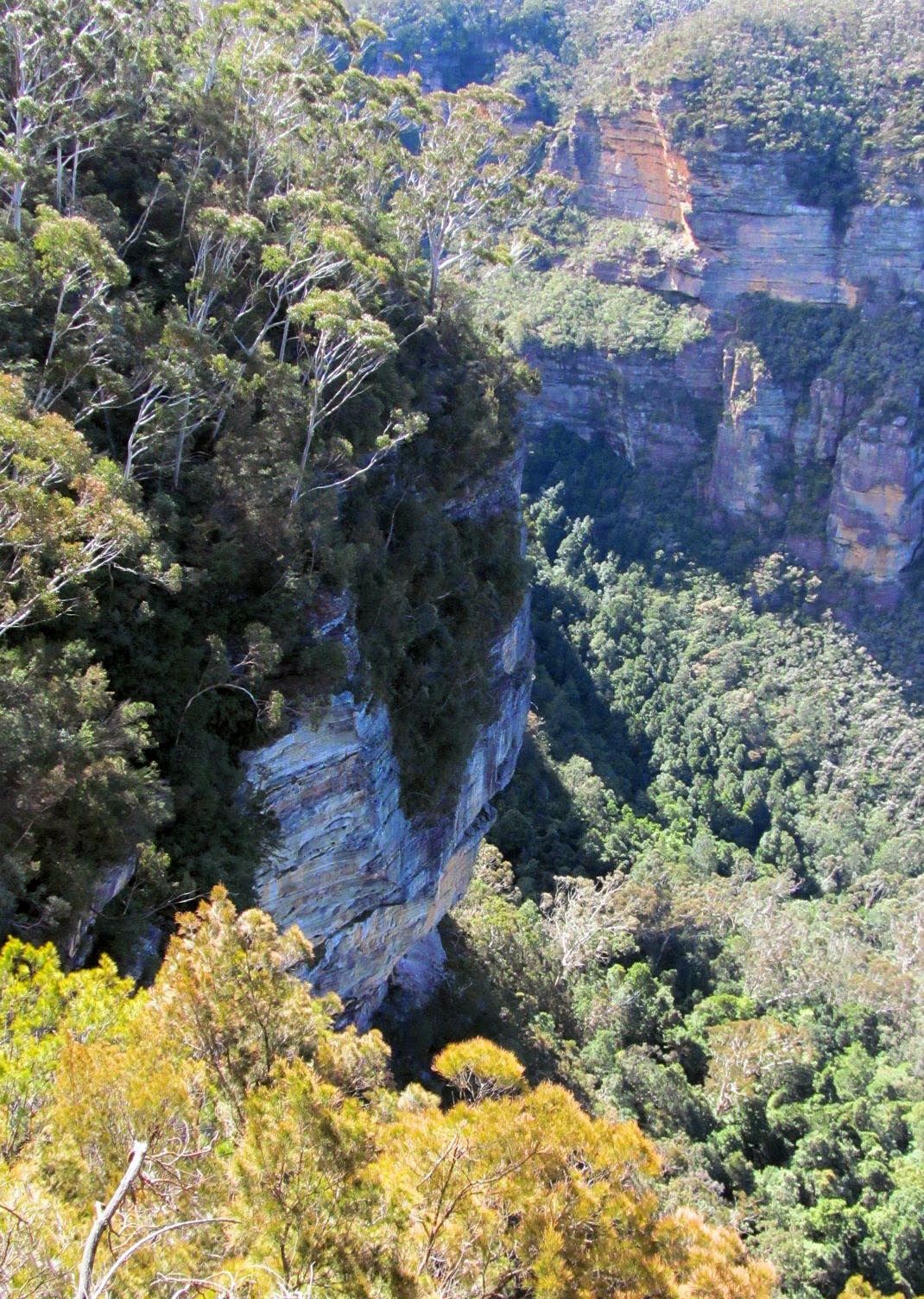
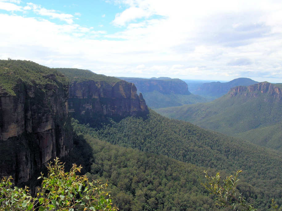
We started at Evans Lookout and walked the cliff-top track to Govetts Leap.


Crossing Govetts Leap Brook


.

The track afforded great views of the Grose Valley along the way


Bridal Veil Falls Blackheath


         Location Map


A route 698 bus ran from outside the Carrington Hotel at Katoomba to Evans Lookout Rd and St Andrews Ave. at Blackheath. It's about 2.8Km from here to the lookout at the end of the road.

The 698 bus also goes to the Blue Mountains Heritage Centre in Govetts Leap Rd.  The centre provides information on the Blue Mountains National Park and surrounding areas, an interactive educational display, video screenings and a gallery. There is also a very easy walking track which starting at this location, which is considered suitable for wheelchairs - see The Fairfax Track

see Blue Mountains Bus for current time table information

Many thanks to our walk leader John.