Showing posts with label Wentworth Falls. Show all posts

Jul 1, 2024

Wentworth Falls - Rocket Point Walk

The Rocket Point lookout walk is a short loop from the Wentworth Falls picnic area. The walk leads you down to the stepping stones at Queens Cascade above the falls. (See Kings Tableland post) We stopped at the small gully just beyond the cascade to eat our lunch with the occasional spray from the water fall being blown in our direction.

Natural Archway

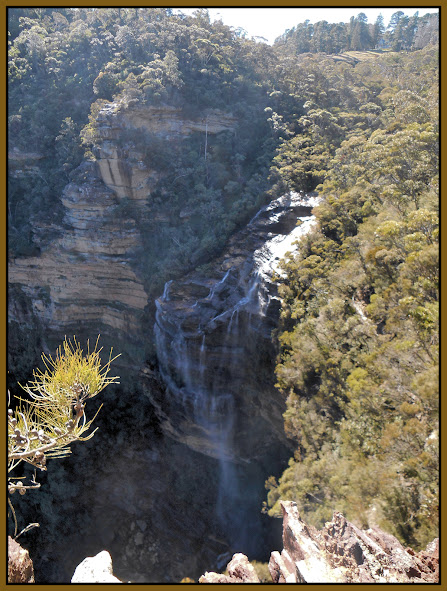
Rocket Point provides a great vantage point to view the falls, as you can see from the photo below.


NSW National Parks and Wildlife Service info                   Wildwalks link


Nov 16, 2013

Wentworth Falls Lake Reserve


Updated 8th January 2015

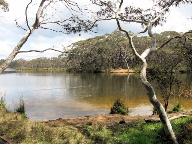
Wentworth Falls Lake was created in the early 1900s to supply water for steam locomotives, by damming Jamison Creek.

Wentworth Falls Lake Reserve has a picnic area and children's playground with sandstone sculptures, based on seed pods of local plant, nearby. There is a walking track around the lake, of about 3.5 Km. in length. (this includes some walking along Waratah & Banksia Rds.)

Much of the lake is surrounded by sensitive hanging swamp, which is listed as an 'Endangered Ecological Community'


                                                 location map


Jun 10, 2012

Charles Darwin Walk Revisited

One of my favorite walks in the Upper Blue Mountains, in a beautiful little gully, leads from a park not far from the Wentworth Falls village centre, down to the falls. 'The swamps of Jamison Creek filter and clean the water that flows over Wentworth Falls, helping to protect rare species.'


Jamison Creek


Weeping Rock

You can see more photos of this walk on my earlier post. A little further than Weeping Rock, you reach a junction, with tracks to lookouts and the picnic ground. This is the starting point for other walks such as the National Pass walk.

        Walk info from Wild Walks                                 Location Map


May 27, 2011

Kings Tableland - Wentworth Falls


Bushwalking in the Blue Mountains on cloudy or misty days can yield some interesting variations from those photos taken on sunny days. On this walk, we started from Wentworth Falls station and followed Darwins Walk, to cross Jamison Creek above Wentworth Falls, then onto Kings Tableland.


An Acacia sp.(left) growing in tough windswept conditions on the edge of Kings Tableland.
The Kings Tableland area is known as a ancient Aboriginal cultural site, with some artefacts from a cave having been dated to 25,000 years old.

Kings Tableland above Jamison Valley


Creek crossing above Wentworth Falls


Queens Cascade (left) on Jamison Creek, just above Wentworth Falls.


            Location map


'Wildwalks' information 


Our thanks to John Masser our walk leader

Feb 23, 2011

Wentworth Falls - National Pass

This walk follows on from the Charles Darwin Walk at Wentworth Falls. (See my earlier post).


The photos were taken on two separate walks, one with a bush walking group and the other by myself, which gave me more time for photography. There was plenty of water in Jamison Creek on both days, after recent rain.

It is only a short distance from the peaceful surrounds of Weeping Rock (left), towards the end of  'The Darwin Walk' track, to the top of Wentworth Falls.


I took a side trip at this point to Fletcher's Lookout, to photograph the falls, before returning to the National Pass track.


Wentworth Falls from Fletcher's Lookout


Wentworth Falls from the National Pass track.

The track, which winds down 'The Grand Stairway' is cut into the cliff, is very popular, at least the section to the bottom of the falls.
Beyond this point the track continues along the cliff-line to the 'Valley of the Waters'. (see map)


We passed a section of the track where, due to the recent rains, we passed behind a water fall.


  We turned off to the 'Conservation Hut Cafe' when we reached the 'Valley of the Waters', then back to the station cutting through Murphy's Lane and Central Park to Falls Road.


This map (in the Falls Reserve picnic area) is provided by the NSW National Parks & Wildlife Service


Wild Walks Info

     Google Map


My thanks to our leader John.

Jan 29, 2011

Charles Darwin Walk - Wentworth Falls


This Blue Mountains walk which starts at Wilson Park at Wentworth Falls, is named after Charles Darwin who visited the area in 1836. The 2.8Km walk follows Jamison creek almost to the top of Wentworth Falls where there are great views of the falls and the National Park. The walk was reopened after the replacement of some of the timber board walk and three foot bridges due to flood damage last year.

Coreopsis
Weeds are a problem in the upper reaches of the creek. Coreopsis (above) is an attractive perennial yellow daisy from USA. Seeds are washed down watercourses and invade open sunny areas crowding out native plants such as those below. 


 Blue Dampiera (Dampiera stricta) shown above, have unusual ‘diamond shape’ leaves. The 'Trigger plant' (Stylidium sp.) left, has a trigger which transfers pollen to insects that lands on the flower.


The walk is also popular with  locals


Jamison Creek, Wentworth Falls

Transport details
Wentworth Falls is about 1hr 50minutes from Central by CityRail Intercity train. 
It may be possible to catch a Route 685 bus back to the station after the walk, by walking up Falls Rd to a bus stop past Fletcher St. See Upper Mts bus timetable (Use 'Valley of the Waters' stop times as a guide)

More information about this walk at WildWalks