Showing posts with label bridges. Show all posts

Jul 25, 2016

Artarmon to Middle Harbour

We started our walk at Artarmon station following a pathway that led us to Flat Rock Creek.


Willoughby Council's  Flat Rock Gully leaflet warns that after rain the creek crossing may not be possible, which was the case for us, as the photo below shows.


I returned on another day to take more photos. The creek flows under Tunks Park, Cammeray and into Middle Harbour at Mortlock Reserve (below).


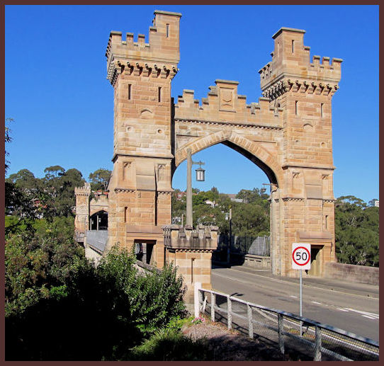
The concrete arch Cammeray bridge (above & below) opened in 1939, replacing  the original 1892 steel suspension bridge built by a private syndicate to promote residential development. The original sandstone turreted towers were retained. The suburb Northbridge takes its name from the bridge.


There are steps leading up to The Boulevarde and Miller Street, where we caught a bus to the City.

                Willoughby Council walking track info                  Location Map
 

Oct 22, 2015

Woronora River

We started our Woronora walk at Jannali station in the Sutherland Shire, south of Sydney, then through the Burnum Burnum Sanctuary (named after the late Aboriginal activist).


The sanctuary 'contains ... a variety of soil conditions supporting a rich diversity of native plant communities from the Sydney Ridgetop Woodland down through Sandstone Gully Forest on the west facing slope to the riverflats and mangroves, interesting rock platforms and caves.'  [Kaimiaway]


I was impressed by the four-lane 521m long Woronoria River Bridge, which includes a wide shared pedestrian walkway and cycleway suspended below the northern deck. The bridge, completed in 2001, won the 2002 Australian Construction Achievement Award. (ACAA)


 Woronora River, Woronora


The pedestrian bridge (above), is at the end of Park Street Woronora.
My GPS trace stops at the reserve on the western bank. We extended our walk from there to the bus stop opposite the RSL club, where we caught a bus to Sutherland station.

                                        Location Map


Jul 9, 2015

Lane Cove River

Pond near Tarban Creek, Huntleys Cove

This walk, which began at Huntleys Point wharf on the Parramatta River, was a new one for me. It followed a section of the Great Northern Walk along the Lane Cove River, to West Chatswood.

Tarban Creek bridge from Huntleys Cove

Lane Cove River
At Epping Road, North Ryde, we crossed under the Lane Cove River Bridge. (above)
------------------------------------------------------------
A little to the north of this, and within Lane Cove Nation Park, is a site once known as the Fairyland Pleasure Grounds - 'a place of mystery and beauty' - the clearing on the banks of the river, once featured a picnic ground, dance hall, flying-fox etc. It dates from 1913, and remained in use until the early 1970s. (below)


We ended our 10.9km walk at Delhi Rd near Fullers bridge, and caught a bus to Chatswood station. My thanks to our walk leader.
                                                 

          location map  (Huntleys Point)           location map  (Lane Cove)        


Nov 21, 2014

Iron Cove 'Bay Run'

'Our Excursions' visited part of 'The Bay Run' in 2010 to photograph Callan Park.  Recently I returned to Lillyfield to meet up with a long time friend, to walk around Iron Cove.     Location map

Iron Cove near King George Park

Iron Cove Run - King George Park

This pleasant 7.2 Km run/walk and cycleway that follows the foreshore around the cove, is mostly flat, apart from the incline up to cross the bridge.

Iron Cove Bridge

http://www.leichhardt.nsw.gov.au/Recreation/Walking-and-Cycling/The-Bay-Run


The current steel truss bridge replaced an earlier wrought iron bridge build shortly after WW2.

Work on the duplication of the Iron Cove Bridge (see left) was completed in January 2011. It's on the western side, has three traffic lanes and a nice wide walkway/cycle path.


Along the walk are signs giving information about Mangroves, Saltmarsh etc found in the intertidal zone around the cove.


Rodd Park - Rodd Point

UTS/Haberfield Rowing Club


We started and finished our walk from the Leichhardt North Light Rail stop, and stopped off at a cafe for lunch. There is also a Club at Habberfield (above)

Bay Run info links - Canada Bay - Leichhardt (with map)


Aug 1, 2014

Knapsack Viaduct - Lapstone


Knapsack Viaduct, completed in 1867, was originally built as a rail bridge, and formed part of the zig-zag* railway at Lapstone, on the Sydney side of the Blue Mountains.

In 1926 this sandstone viaduct, designed by the railway engineer John Whitton, was widened to accommodate use as a road bridge. The viaduct remained part of the Great Western Highway until 1993, when it was replacing by a section of the M4 Western Motorway.

                                           Elizabeth lookout

The viaduct, 57Km from Sydney, is now a pedestrian path/cycleway which continues down the hill to the end of the Great Western Highway at Emu Plains.  Lucasville platform (left), can still be seen nearby.
When the first Glenbrook deviation was opened in 1892, the Lapstone ZigZag was abandoned, and John Lucas (Minister for Mines), lost the convenient rail link to his country retreat.                   

location map            'WildWalks' notes             

* Sometimes known as the "Little Zig-Zag" to avoid confusion with the Zig-Zag railway on the western side of the Mountains                                             

Aug 6, 2013

Rozelle Bay to Pyrmont Bay

We started this walk at Rozelle light rail station, and mostly followed the Glebe foreshores around Rozelle and Blackwattle Bays to Wentworth Park.   Location map


Anzac Bridge


(above left) Bellevue House on Blackwattle Bay (includes a cafe)
(above right) James Craig, a three-masted, iron-hulled barque, restored and sailed by the Sydney Heritage Fleet

Our group extended the walk, cutting through Pyrmont to Johnstons Bay, and ending at Pyrmont Bay light rail station.
(below) Wind turbine - Glebe foreshore
 
[Worth a look: At Pyrmont Point Park we passed Tied To Tide, a kinetic artwork activated by tide, wave and wind]

Mar 2, 2013

Seacliff Bridge

My first visit to the Sea Cliff Bridge, north of Wollongong, was with a walking group. We caught a train on the South Coast line, to Scarborough station, about 60 Km from Sydney Central.

Scarborough Station NSW

Seacliff Bridge, Lawrence Hargrave Drive


The Sea Cliff Bridge, was opened in 2005. It was built away from the cliff faces, to eliminate the danger of falling rocks and slippages which afflicted the previous coast road.


This photo and the top photo, were taken when I returned on a showery day recently.


This spectacular walk from Scarborough, past Clifton to Coalcliff, was less than 2Kms.

Seacliff Bridge info site    


 SCBWebcam


We caught a bus at Coalciff, back to Thirroul station, to return to Sydney. My thanks to Jean B. for leading us on this walk.

Dec 9, 2010

Parramatta River at Parramatta

Barry Wilde Bridge, Parramatta

These three bridges near the city's centre, cross a short stretch of the Parramatta River above the Charles Street weir, 19Km upstream from Port Jackson.

The bridge in the photo above was named after a former mayor and state politician. The pathway in the foreground is part of the 'Riverside Walk' which leads from the ferry wharf  to the 'Heritage Centre' next to Lennox bridge. Through art and interpretive signs it tells the aboriginal history of the area.


The Elizabeth Street footbridge is an award winning cycle and foot bridge which features an interesting public artwork .

'Wake' by Greg Stonehouse and Susan Milne was inspired by "the gliding movement of oars" and the "flight of birds".


      Lennox bridge (below) was designed by the colony's first Superintendent of Bridges, David Lennox.
It has since been modified but was originally completed in 1839.

Lennox Bridge, Parramatta


                                            See also my 'RiverCat' and 'Parramatta Park' posts     
 
  Location map              Additional photo of footbridge