Showing posts with label waterfalls. Show all posts

Jul 1, 2024

Wentworth Falls - Rocket Point Walk

The Rocket Point lookout walk is a short loop from the Wentworth Falls picnic area. The walk leads you down to the stepping stones at Queens Cascade above the falls. (See Kings Tableland post) We stopped at the small gully just beyond the cascade to eat our lunch with the occasional spray from the water fall being blown in our direction.

Natural Archway

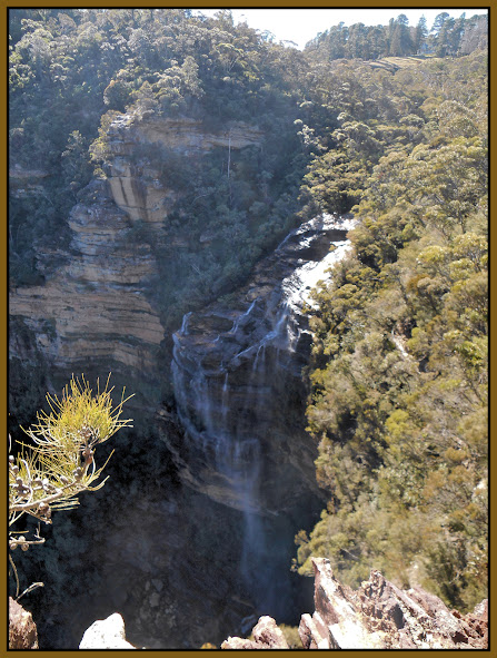
Rocket Point provides a great vantage point to view the falls, as you can see from the photo below.


NSW National Parks and Wildlife Service info                   Wildwalks link


May 5, 2012

South Lawson Waterfalls

The waterfalls on this popular walk at Lawson in the Blue Mountains, were looking great after recent heavy rain. Unfortunately a bridge over the creek had been washed away, but as we saw stockpiles of sandstone blocks near the track, I expect repairs to the track will not be too far away.

Adelina Falls


Federal Falls


Cataract Falls, Lawson


I have had lunch at Federal Falls before in the summer, but it was too cool and shady on this occasion, so we climbed further up the hill and stopped for lunch there.

The waterfalls circuit can be completed by returning to Lawson along Honour Avenue, or by walking along fire trails and roads to Hazelbrook, as our group did.


location map

My GPS trace 


This walk can also be extended to join the Terrace Falls walk at Hazelbrook.
(see my Lawson to Hazelbrook post)


Aug 10, 2011

Leura Falls Walk

This walk in the Upper Blue Mountains, follows the Leura section of the Prince Henry Cliff Walk for around 2Kms, and has great views from lookouts along the way. My first blog post described part of the Katoomba end of this walking track.

View into Jamison Valley


Bridal Veil Falls, Leura

Banksia spinulosa

Another view from Bridal Veil Lookout

Tarpeian Rock Lookout

We started this walk at Gordon Falls Reserve (near the end of Lone Pine Ave.) about 2Km from Leura train station. To finish our walk we turned off the The Prince Henry Cliff Walk, and walked up past the Leura Cascades to the Picnic Area. The Leura Cascades is my banner photo at the top of this blog.

Once back in Leura Mall there is no shortage of cafes.

Wildwalks notes describe the reverse route. The walk to Tarpeian Rock and Bridal Veil Lookouts can also be done as as short walk from Cliff Drive.

May 27, 2011

Kings Tableland - Wentworth Falls


Bushwalking in the Blue Mountains on cloudy or misty days can yield some interesting variations from those photos taken on sunny days. On this walk, we started from Wentworth Falls station and followed Darwins Walk, to cross Jamison Creek above Wentworth Falls, then onto Kings Tableland.


An Acacia sp.(left) growing in tough windswept conditions on the edge of Kings Tableland.
The Kings Tableland area is known as a ancient Aboriginal cultural site, with some artefacts from a cave having been dated to 25,000 years old.

Kings Tableland above Jamison Valley


Creek crossing above Wentworth Falls


Queens Cascade (left) on Jamison Creek, just above Wentworth Falls.


            Location map


'Wildwalks' information 


Our thanks to John Masser our walk leader

Mar 26, 2011

Evans Lookout to Goverts Leap

I completed this walk at Blackheath in the Upper Blue Mountains with an NPA bush-walking group.
We started at Evans Lookout and walked the cliff-top track to Govetts Leap.


Crossing Govetts Leap Brook


.

The track afforded great views of the Grose Valley along the way


Bridal Veil Falls Blackheath


         Location Map


A route 698 bus ran from outside the Carrington Hotel at Katoomba to Evans Lookout Rd and St Andrews Ave. at Blackheath. It's about 2.8Km from here to the lookout at the end of the road.

The 698 bus also goes to the Blue Mountains Heritage Centre in Govetts Leap Rd.  The centre provides information on the Blue Mountains National Park and surrounding areas, an interactive educational display, video screenings and a gallery. There is also a very easy walking track which starting at this location, which is considered suitable for wheelchairs - see The Fairfax Track

see Blue Mountains Bus for current time table information

Many thanks to our walk leader John.

Feb 23, 2011

Wentworth Falls - National Pass

This walk follows on from the Charles Darwin Walk at Wentworth Falls. (See my earlier post).


The photos were taken on two separate walks, one with a bush walking group and the other by myself, which gave me more time for photography. There was plenty of water in Jamison Creek on both days, after recent rain.

It is only a short distance from the peaceful surrounds of Weeping Rock (left), towards the end of  'The Darwin Walk' track, to the top of Wentworth Falls.


I took a side trip at this point to Fletcher's Lookout, to photograph the falls, before returning to the National Pass track.


Wentworth Falls from Fletcher's Lookout


Wentworth Falls from the National Pass track.

The track, which winds down 'The Grand Stairway' is cut into the cliff, is very popular, at least the section to the bottom of the falls.
Beyond this point the track continues along the cliff-line to the 'Valley of the Waters'. (see map)


We passed a section of the track where, due to the recent rains, we passed behind a water fall.


  We turned off to the 'Conservation Hut Cafe' when we reached the 'Valley of the Waters', then back to the station cutting through Murphy's Lane and Central Park to Falls Road.


This map (in the Falls Reserve picnic area) is provided by the NSW National Parks & Wildlife Service


Wild Walks Info

     Google Map


My thanks to our leader John.

Nov 28, 2010

Lawson to Hazelbrook Bushwalk


    These photos were taken on a walk in the mid Blue Mountains starting at Honour Ave. Lawson. The walk combined the popular South Lawson waterfalls circuit with the Terrace Falls walk to finish at Hazelbrook station.
Terrace Falls, Hazelbrook


Reference books that cover walks in this area include a book by Robert Sloss, another by Veechi Stuart & one published by the National Parks Association:  'Bushwalks in the Sydney Region' Vol 2

Sep 22, 2010

Katoomba - Furber Steps to 'Witches Leap'


Witches Leap, Katoomba

There are numerous bush walks around the Echo Point and Scenic World area. My ‘Echo Point’ post mentioned one, the Prince Henry Cliff walk.

This current post shows a few photos taken on a walk from the Katoomba Falls Kiosk on Cliff Drive, down the Furber Steps  past 'Witches Leap' into the rainforest at the base of the cliff. A sign along the way informed us that a ‘leap’ is a Scottish term for waterfall
The Three Sisters


The familiar silhouette of the Three Sisters is seen (from a distance) from a lookout below Katoomba Falls Park.

Location map for the walk

Katoomba Falls

'Wild Walks' site gives details of many bush walks in the area including 'Witches Leap Circuit' starting at Scenic World.  

Jun 26, 2010

North Lawson Waterfalls


For this excursion the train trip from Sydney's Central station to Lawson in the Blue Mountains, took about 1hr 45mins. This walk started beyond the Swimming Centre at the end of St Bernard's Drive, on the northern side of Lawson station.


  The north Lawson walking tracks are quite rough in places, but it is a very pleasant walk even on a cloudy day, as you can see from the photos. The bush walk we did was 7Km, but this will vary depending on the route taken. If you would like a short walk just walk to 'Fairy Falls' and return the same way.


Most of the walking group I was with had a coffee or hot chocolate at this cafe before catching the train home. (It's behind the shops in Honour Ave)