Dec 22, 2012

Sculpture by the Sea, 2012 (3)


This is my third and final post of sculptures from this year's Sculpture by the Sea exhibition.
Most were situated in or near Mark's Park which is about half way on the walk between Tamarama and Bondi Beaches. We sought out some shade for our lunch break at this spot.

Philip Spelman - tete-a-tete


Hilde A. Danielsen - upside down again


Hilde A. Danielsen - upside down again (above and below left)

Kate Dunn - regenerate (below)


Sue Roberts - the listrumpet


Keizo Ushio - oushi zokei 2012 twice twist bands


Subodh Kerkar - the chilly

'The Portuguese brought chillies to Goa, which were disseminated all over the country, making India the largest producer of chillies in the world.' - from the artist's statement in the catalogue.  
By the way, it is spelt "chilly" in the catalogue

R.M. (Ron) Gomboc - repose


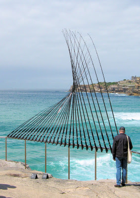
Cave Urban - mengenang (memory)

The wind-driven installation, shown above, is part of 222 bamboo 'bird-scarers' tuned to D-minor, 'which began as a reflection on the 222 lives lost in the Bali bombings'  - from the artist's statement in the exhibition catalogue. Bondi beach is seen in the background.

Dec 9, 2012

Sculpture by the Sea, 2012 (2)


The Bronte to Bondi coastal walk is a very scenic walk which can be enjoyed most days, not just when 'Sculpture by the Sea' is on.

Dave Mercer - ViewTM


(photo above) The artist's statement from the catalogue: "It often seems that even the most basic of human experiences need to be branded in order to seem important and valid."

Greer Taylor - transition


Mike MacGregor - finding alternatives (3 elements) 2011

Hidemi Tokutake - gregarious


Zhang Yangen - sea's nest


Rachel Couper & Ivana Kuzmanovska - mirador

'Mirador', which is made of plywood, timber and perspex, was created by two Master of Architecture graduates who are interested in the relationship between architecture and art.


Nov 26, 2012

Sculpture by the Sea, 2012 (1)

Sculpture by the Sea (Bondi) was held from 18th October - 4th November 2012, along the 2km coastal walk between Bondi and Tamarama beaches. The exhibition featured over 100 sculptures by Australian and international artists.
The sculptures shown in this post were on or near Tamarama beach.

Above: Michael Dickson - sculpture:shelter (foreground
Mark James Emery - bamboo waves (centre)
Karin van der Molen -surprise  (top left)
Joan Costa - alga infinita (top right)


Michael Purdy - spinal column (right)
'This sculpture is about growth'


Linda Bowden - reclining figures (below)


Staccato - poom  (above and left)

Four graduating students from the College of Fine Arts, Chung-Ang University, South Korea.
The motif comes from a Korean children's game. Made from used clothes covering a steel frame.


Alex Ritchie - kaleidoscope cube (below)

Made from polished aluminium, the sculpture 'allows viewers an extraordinary variety of reflective views'.

Ruth Downes & Geoff Webster - casting around (below)


Nov 16, 2012

Woodford - Transit of Venus

We started this bush walk at the end of Clearview Parade Hazelbrook (below)


The track is so called, because an observatory was set up not far from the Woodford Academy, to house a 114mm telescope and other instruments, needed for the observation of the 9th December 1874 Transit of Venus.

The passing of Venus between the Sun and Earth, was an important event, as it enabled scientists to better calculate the distance from earth to the sun.

The most recent Transit of Venus occurred in June 2012, and will not occur again until 2117.

Along the way we passed Waratahs (Telopea) in flower, and visited Edith Falls (below right) and a side trip to Mabel Falls, where we ate our lunchs.


Our walking track crossed the fire trail (above) in Mabel Falls Reserve. The track ended at Woodbury Street with a steep climb back to the highway. We finished at Woodford station.

Location Map
 
My thanks to Judith and Jenny for showing us this lesser known track, with its historic connections. 

Nov 2, 2012

Centennial Park

Centennial Park, situated in Sydney's eastern suburbs, was dedicated as a public open space in 1888. The park's construction was implemented by Charles Moore, then Director of the Royal Botanical Gardens, on what was then  "coastal shrub land and swamp." The land was "cleared and sculpted into an open, undulating expanse to provide recreation in an idealised setting,"


The Parklands now support a diverse range of activities including horse riding, bike riding, rollerblading, bird watching, and a range of sports.

The Federation Pavilion (above) is located within a huge 'dog off the leash' area (although the dogs are not permitted within 10 metres of the pavilion). Built in 1988, it was designed by Sydney architect Alexander Tzannes as a Bicentennial refurbishment, after he won a competition to design a permanent monument to commemorate the Federation of Australia.


If you plan to visit, it would be well worth reading 'About the Pavilion', which explains the dome's artwork and the inscription.


The woodland of paperbarks (below) is part of Lachlan Swamps, which became a source of fresh water for Sydney (from 1837 to 1859). This difficult task was a  achieved with the completion of Busby's bore; a tunnel running from the marsh to Hyde Park.


Busby's Pond, Centennial Park

Black Swans


Formal gardens, Centennial Park

I was surprised that it took us less than 15 minutes to walk to the parkland from Bondi Junction station, after a 10 minute train ride from the city.

               Location map                                     Transport                                   Parklands map

Oct 19, 2012

Bonnie Doon Cliff Walk

We started this Katoomba walk at the Explorers Tree near the Great Western Highway, at Nellies Glen Road, about 2.5Km from the railway station.

View from Norths Lookout, Katoomba
Nellies Glen Road, which we turned off to follow this cliff top walk, leads to the start of the 'Six Foot Track' and into the valley. Our walk featured Norths Lookout, which overlooks Nellies Glen and the Megalong valley.


Returning to the town centre through Catalina Park (Walford Park) we saw what remains of the Catalina Racing Circuit (below left), which closed in the 1990s. It has a disturbing history, as in 1957 "the traditional owners were forcibly removed from the Gully to make way for a racetrack". This site, known as 'The Gully' was declared an official Aboriginal Place in 2002.


Enlarged photos of the sign the walkers are reading

Location map

WildWalks link


Our thanks, as always, go to our walk leaders.

Oct 1, 2012

Watsons Bay and Sydney's South Head

  We arrived by ferry at Watsons Bay on Sydney Harbour, as an extension to our visit to Garden Island.

Watsons Bay, Sydney Harbour

          We walked along the beach, passing through Green Point Reserve to Camp Cove, then followed the South Head Heritage Trail which starts at the end of the beach.

Camp Cove, Sydney Harbour


The Hornby Lighthouse at South Head, was built following the loss of many lives from two ship wreaks in 1857.

The gun emplacements, completed in 1854, were never equipped with guns. In the photo below we are looking across to North Head.


Location Map             Wildwalks info.               

Sep 3, 2012

Glenbrook Creek to Red Hands Cave

To vary this well known walk in the lower Blue Mountains, our group descended to Glenbrook Creek down the steep slope from the West Glenbrook Nature Reserve (below left).


We followed the creek (above right) to the causeway. The track along the creek was overgrown until after Blue Pool, and although its picturesque, you don't have to reach the causeway by this route.     (see the links at the bottom of the page).

                  
                                      Glenbrook Creek (above)     Campfire Creek (below)


From the causeway we walked the Campfire Creek track to Red Hands Cave, before returning to the station along Bruce Road via the park entrance.      


             Location map

    NSW National Parks: Red Hands Cave            Wildwalks link     


Aug 11, 2012

Taronga Zoo to Clifton Gardens

We started this harbour side walk by catching a ferry to Taronga Zoo wharf. We first walked part of the Curlew Camp Artist's Walk in Sirius Cove Reserve, before retracing our steps.           Location map 
          

From the wharf we followed the path past the lower Zoo entrance to Bradley's Head. A 'Memorial Mast' dominates Bradley's Head. The mast was removed from Sydney (I) when decommissioned in 1928, and was erected at Bradley's Head in 1934. The memorial represents a mark of respect and recognition of the Australian officers, sailors and ships lost at sea and in combat

HMAS Sydney (II) Memorial plaque

Fig tree, Bradley's Head

     Bradley's Head also has stonework from old military fortifications (see info at Mosman CEFE)

Taylors Bay, Sydney Harbour

Clifton Gardens Reserve, Chowder Bay

This is a 5 Km walk took us through part of Sydney Harbour National Park (map and audio tour). At Cliffton Gardens we caught a 244 bus back from Chowder Head Bay Road to the City. You could also return to the Zoo wharf, see WildWalks.

My thanks to our leaders for this very picturesque walk. While this post is another Sydney walk, we have not stopped walking in the Blue Mountains, having recently walked at Springwood, and revisited the Witches Leap walk at Katoomba.