Pages

Dec 3, 2014

Wascoe Siding

Preparing the locomotives

Wascoe Siding is a miniature railway situated in a former railway cutting. The deviation and refuge siding between Glenbrook and Blaxland in the Lower Blue Mountains, was in use for twenty years from 1913.


The area was acquired in the 1960s by the founder of the Blue Mountains Railway Society, which celebrated its 50th birthday this year.
The society hold open days running model steam and battery operated locomotives, such as the impressive models shown in these photos, on the first Sunday of the month, (except in January, wet weather & fire-bans).


The open days are quite popular for family outings and children's birthday parties. A charge is made for the train rides, but entry to the grounds is free. All passengers are required to wear "fully enclosed shoes" to ride the trains. 


                              Wascoe Siding Facebook                  Location Map    
 

Nov 21, 2014

Iron Cove 'Bay Run'

'Our Excursions' visited part of 'The Bay Run' in 2010 to photograph Callan Park.  Recently I returned to Lillyfield to meet up with a long time friend, to walk around Iron Cove.     Location map

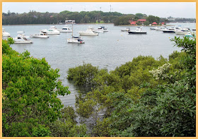
Iron Cove near King George Park

Iron Cove Run - King George Park

This pleasant 7.2 Km run/walk and cycleway that follows the foreshore around the cove, is mostly flat, apart from the incline up to cross the bridge.

Iron Cove Bridge

http://www.leichhardt.nsw.gov.au/Recreation/Walking-and-Cycling/The-Bay-Run


The current steel truss bridge replaced an earlier wrought iron bridge build shortly after WW2.

Work on the duplication of the Iron Cove Bridge (see left) was completed in January 2011. It's on the western side, has three traffic lanes and a nice wide walkway/cycle path.


Along the walk are signs giving information about Mangroves, Saltmarsh etc found in the intertidal zone around the cove.


Rodd Park - Rodd Point

UTS/Haberfield Rowing Club


We started and finished our walk from the Leichhardt North Light Rail stop, and stopped off at a cafe for lunch. There is also a Club at Habberfield (above)

Bay Run info links - Canada Bay - Leichhardt (with map)


Oct 30, 2014

Balmoral to Middle Head

This blog has looked at North Head several times as well as South Head, but until recently I had never visited 'Middle Head' opposite the entrance to Sydney Harbour.

Hunters Park Rotunda


Our walk of around 3.5Km started at Balmoral Beach, followed the path around Balmoral Oval, through Balmoral Park (map link) then up a long series of steps to the ridge top. (see photos below)


Balmoral Beach


To see the spectacular view from above Obelisk Bay (below), we took the side path that leads down to Chowder Bay and Taronga Wharf (see earlier post), before returning to Middle Head Rd.


Historic gun emplacements, Middle Head

    Location map

Middle Head is part of Headland Park, on land formerly occupied by Defence bases. Tunnels and gun emplacements can be seen at the end of Old Fort Rd. and there are other unfenced gun pits around the site.
The fortifications were mostly built between 1870 and 1911.


See also Rocky Point Is. post                                                       'Wildwalks' info


We caught a 244 (Chowder Bay to City) bus back from Middle Head Rd.  (map link)   Doing the walk in reverse may be easier.           

Oct 8, 2014

Australian Botanic Garden (3)


Mount Annan was once part of Glenlee estate, acquired by James Fitzpatrick in the 1850s. His descendants ran a dairy farm on the estate until 1978. Beyond the area near the Visitor Centre, Cafe & Restaurant, is an extensive site of over 400ha scatted with feature gardens such as the Banksia & Grevillea Gardens.


Under the shade of a 'Peppercorn tree'
Although the Peppercorns are from South America, they were commonly grown in Australia as shade trees. The gently undulating hills and small lakes add to the charm of the area.


Another feature of interest is the Sundial of Human Involvement.  The person in the photo above is standing on the spot indicated by the date, facing in the direction of their shadow, with arms stretched above their head.


Sep 28, 2014

Australian Botanic Garden (2)

White Faced Heron with 'Kangaroo paws' behind

After my earlier enjoyable visit to the Australian Botanic Garden at Mount Annan, I have wanted to return in better weather. This post has some photos from my return visit to see the spring flowers and complete a longer walk around the site. 

The Wattle Garden picnic area
Lechenaultia biloba


Garden near visitor centre


Australian Botanic Garden
    -map          -information


PlantBank visit 


'Everlastings' or 'paper daisies'


Sep 11, 2014

Rocky Point Island - Balmoral


Rocky Point Island separates Edwards Beach from Balmoral Beach on Hunters Bay, Middle Harbour. The small island is connected to the Esplanade by a bridge, built as a government employment project during the Great Depression, as was the Bathers’ Pavilion.


Rocky Point Island, looking towards Sydney Heads
The Mediterranean style 'Bathers' Pavillion' on Edwards Beach (below), was built in 1929, and now houses a restaurant, cafe and function rooms. See also Balmoral to Middle Head post


 I travelled to Balmoral by ferry to Taronga Zoo, then bus from the wharf
and returned by bus to Wynard station.  


  Location Map (Chrome)

Ref: Mosman Historical Society - 'Historic Guide to Balmoral'

Aug 27, 2014

Statues of Dogs, and 'Trim' the cat

The following pictures are a collection of dog and cat statues we have come across, on walks around Sydney. 


In a busy part of Sydney, outside the Queen Victoria Building, near a statue of Queen Victoria herself, is a statue of her favourite dog 'Islay'. The statue presides over a wishing well, with donations going to Royal Institute for Deaf and Blind Children.    [c.1987 by Sydney sculptor Justin Robson]  


'Biggles' (1980 - 1994) the subject of this statue, can be found at the corner of Atherden and Playfair Streets. I'm not sure how he managed to roam The Rocks, but he was regarded as a loved friend, among the residents and shopkeepers of the area. location map
[c.1995 by artist, Anne Dybka] Ref: monumentaustralia


 A plaque near Central Station tells us 'Donna' (1975 – 1995) (below), was a hearing guide dog, the friend and constant companion of John Hogan of Pyrmont, who travelled on trains extensively, throughout NSW.
 The memorial also recognises the love and companionship that all Guide Dogs give to the visually and hearing impaired.
(Sculptor: Ian Shaw)


 “For 17 years (1953 – 1978) ‘Billy’ (above) was a familiar figure in Mosman as he went on the daily rounds beside his master, Cliff Williams, a street sweeper. The statue was given a gift as a reminder of the reliance of animals on man and the debt mankind owes to animals.”  - memorial plaque.  [Billy, c. 1978 by Denis Adams]  Located in Balmoral Beach Reserve. location map


Next to the State Library, in busy Maquarie Street, is a statue of 'Trim', Matthew Flinders’ intrepid cat who circumnavigated Australia with his master 1801 -1803.  [c.1996 by sculptor John Cornwell]

The best and most illustrious of his race, the most affectionate of friends, faithful of servants, and best of creatures. He made the tour of the globe, and voyage to Australia, delight and pleasure of his fellow voyagers…


'Foxie', a bronze sculpture by artist Clary Akon, was commissioned in 2006 to adorn the pedestal of the  'Jessie Broomfield Memorial Dog Drinking Fountain' built by North Sydney Council in 1953. We passed through Bradfield Park North, Milsons Point, early this year, on our way to visit Wendy's Garden. (view post)

Aug 1, 2014

Knapsack Viaduct - Lapstone


Knapsack Viaduct, completed in 1867, was originally built as a rail bridge, and formed part of the zig-zag* railway at Lapstone, on the Sydney side of the Blue Mountains.

In 1926 this sandstone viaduct, designed by the railway engineer John Whitton, was widened to accommodate use as a road bridge. The viaduct remained part of the Great Western Highway until 1993, when it was replacing by a section of the M4 Western Motorway.

                                           Elizabeth lookout

The viaduct, 57Km from Sydney, is now a pedestrian path/cycleway which continues down the hill to the end of the Great Western Highway at Emu Plains.  Lucasville platform (left), can still be seen nearby.
When the first Glenbrook deviation was opened in 1892, the Lapstone ZigZag was abandoned, and John Lucas (Minister for Mines), lost the convenient rail link to his country retreat.                   

location map            'WildWalks' notes             

* Sometimes known as the "Little Zig-Zag" to avoid confusion with the Zig-Zag railway on the western side of the Mountains                                             

Jul 5, 2014

Fungi


Late autumn and early winter is a good time for observing and enjoying the different forms and colours of fungi. This post is a small collection of photos I have taken on different walks, and as you might be able to tell, some were taken on bush walks and the others on urban walks.

Amanita muscaria


Coral Fungi


Stinkhorn fungi

  Some informative blogs:  'Fungimap's Blog' and Australian Fungi Blog