 |
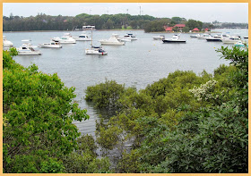
| Iron Cove near King George Park |
 |
| Iron Cove Run - King George Park |
This pleasant 7.2 Km run/walk and cycleway that follows the foreshore around the cove, is mostly flat, apart from the incline up to cross the bridge.
 |
| Iron Cove Bridge |
The current steel truss bridge replaced an earlier wrought iron bridge build shortly after WW2.
Work on the duplication of the Iron Cove Bridge (see left) was completed in January 2011. It's on the western side, has three traffic lanes and a nice wide walkway/cycle path.
Along the walk are signs giving information about Mangroves, Saltmarsh etc found in the intertidal zone around the cove.
 |
| Rodd Park - Rodd Point |
 |
| UTS/Haberfield Rowing Club |
We started and finished our walk from the Leichhardt North Light Rail stop, and stopped off at a cafe for lunch. There is also a Club at Habberfield (above)
Bay Run info links - Canada Bay - Leichhardt (with map)


No comments:
Post a Comment