Pages

Mar 24, 2013

Woodford Academy

Woodford Academy, dates back to the 1830s, making it the oldest group of buildings in the Blue Mountains. It's first use was as an inn called the 'Woodman', which served travellers on their way between Sydney and the western plains. It has had many owners and has served many other uses since then, including: a school, a guest house and a private residence.


The the railway station, adopted the name Woodford in 1871, after the renamed 'Woodford House', then owned by Alfred Fairfax. It latter became 'Woodford Academy', a school for 'young gentleman'.


In 1979 it was gifted to the National Trust of Australia, which has renovated and maintained the heritage property.


    Woodford Academy Open Days                Mid Mts Historical Soc.                      Location map

My thanks to the volunteer guides from Friends of Woodford Academy

Ref.  'A Brief History of Woodford Academy' - Friends of Woodford Academy

Mar 17, 2013

Toongabbie Creek

 in the Upper Parramatta River catchment.


Unless you visit the area, or are a local, you are unlikely to have heard of the 'Redbank Track', which runs along the upper reaches of the Parramatta River and Toongabbie Creek, behind the Westmead Health Precinct.


The photo above was taken at the junction of the Parramatta River, with the Darling Mills and Toongabbie Creeks.


The concrete piers, on both the Westmead and Northmead sides of the Toongabbie Creek, are probably all that remain of the Parramatta to 1923 - 1932 Rogans Hill Railway Line.


The Mons Rd bus bridge is part of the North-West T-Way, which provides a bus only corridor between Parramatta and Rouse Hill.

Location Map

Darling Mills Ck 

Toongabbie Creek

North West T-Way


Our walking group started and finished on the Westmead side of Parramatta Park, near the Wisteria Gardens in the Cumberland Hospital grounds. (This is where they hold their fete in September). We crossed the creek at Redbank Rd. and Mons Rd. to complete a loop. Plant communities along the creek are varied, as it lies in a transition zone between soil types and rainfall areas. While I didn't find the walk along a section of the creek particularly scenic (plastic bags from urban runoff, were snagged in trees along a section), I thought it was worth doing.

Mar 2, 2013

Seacliff Bridge

My first visit to the Sea Cliff Bridge, north of Wollongong, was with a walking group. We caught a train on the South Coast line, to Scarborough station, about 60 Km from Sydney Central.

Scarborough Station NSW

Seacliff Bridge, Lawrence Hargrave Drive


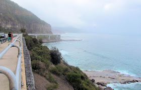
The Sea Cliff Bridge, was opened in 2005. It was built away from the cliff faces, to eliminate the danger of falling rocks and slippages which afflicted the previous coast road.


This photo and the top photo, were taken when I returned on a showery day recently.


This spectacular walk from Scarborough, past Clifton to Coalcliff, was less than 2Kms.

Seacliff Bridge info site    


 SCBWebcam


We caught a bus at Coalciff, back to Thirroul station, to return to Sydney. My thanks to Jean B. for leading us on this walk.