Pages

Dec 9, 2010

Parramatta River at Parramatta

Barry Wilde Bridge, Parramatta

These three bridges near the city's centre, cross a short stretch of the Parramatta River above the Charles Street weir, 19Km upstream from Port Jackson.

The bridge in the photo above was named after a former mayor and state politician. The pathway in the foreground is part of the 'Riverside Walk' which leads from the ferry wharf  to the 'Heritage Centre' next to Lennox bridge. Through art and interpretive signs it tells the aboriginal history of the area.


The Elizabeth Street footbridge is an award winning cycle and foot bridge which features an interesting public artwork .

'Wake' by Greg Stonehouse and Susan Milne was inspired by "the gliding movement of oars" and the "flight of birds".


      Lennox bridge (below) was designed by the colony's first Superintendent of Bridges, David Lennox.
It has since been modified but was originally completed in 1839.

Lennox Bridge, Parramatta


                                            See also my 'RiverCat' and 'Parramatta Park' posts     
 
  Location map              Additional photo of footbridge


Nov 28, 2010

Lawson to Hazelbrook Bushwalk


    These photos were taken on a walk in the mid Blue Mountains starting at Honour Ave. Lawson. The walk combined the popular South Lawson waterfalls circuit with the Terrace Falls walk to finish at Hazelbrook station.
Terrace Falls, Hazelbrook


Reference books that cover walks in this area include a book by Robert Sloss, another by Veechi Stuart & one published by the National Parks Association:  'Bushwalks in the Sydney Region' Vol 2

Nov 16, 2010

'Kirkbride' - Callan Park (3)

Kirkbride - Medical Officers wing (Matron's House)
The Medical Officer's wing (above & below) was the Administation building of Sydney College of the Arts.
  The SCA have moved to the Camperdown/Darlington Campus  in the Old Teachers College building. What will happen to the Kirkbride site?


The SCA Auditorium (below) was originally the Recreation Hall and has a semi-circular dome with Victorian stain glass window.


See my previous post on 'Kirkbride' for more


                                     'Friends of Callan Park'

Nov 7, 2010

Blackheath Rhododendron Gardens


The eight hectare 'Campbell Rhododendron Gardens' at Blackheath in the upper Blue Mountains was established by the Blue Mountains Rhododendron Society and is maintained by volunteers. The site is much larger than this and has walking trails around the garden and bushland.

One of the things that struck me when visiting was the good effect of the exotic plants set within the Australian bushland.


Waratahs


April - May and September to November are likely to be the best times of the year to visit, but it is open all year.

The garden features a large pond and tranquil areas suitable for a picnic. Admission was just $5 (2024) at the Information Booth.

Location map


Oct 30, 2010

'Kirkbride' - Callan Park (2)

The 'Kirkbride' block, built in 1885, covers five hectares. It was part of the original ‘Callan Park Hospital for the Insane’


The buildings are built with sandstone mainly quarried on site and have slate roofs.
When Kirkbride opened in 1884 it represented reform in psychiatric practice, being the first to be designed as a curative and therapeutic environment based. Conditions at the hospital deteriated latter on, I am told.

It was named after Dr Thomas Kirkbride an American advocate for the mentally ill.


"Kirkbride features a pavilion-type plan, arranged around interlinked courtyards. Sunlight and air were seen to bring general moral benefits to asylum patients, and the buildings are well-lit and airy and open onto verandahs that link the various courtyards."

The original furnace stack is seen beyond the courtyard (right). The furnace was used to generate steam for the laundry.
The Kirkbride complex continued to be used for patients until 1994.
It was transferred to the Sydney College of the Arts in 1996 after renovations and restoration work and is now part of the University of Sydney.


Overlooking the site is the Venetian ‘clock tower’ which has a tidal ball copper spire on top, which rises and falls according to the water level of the underground reservoir below. Water entered the two underground tanks collected from the surrounding roofs, via downpipes concealed as Doric columns supporting the verandahs, and was pumped into two large cast iron water in the tower. The water was then gravity fed to the wards, with the upper tank reserved for any fire emergency. While there is provision for clocks, they were never installed.


 Reference: SCA pdf booklet 'Kirkbride - Past and Present'                  SCA transport information link

The Historic Houses Trust conducted tours of SCA in November as part of  'Sydney Open'

Oct 17, 2010

Mt. Victoria - Cox’s Cave

This Blue Mountains bush walk at Mt. Victoria starts at Mt. Piddington Reserve, which is about 2Kms from the railway station. The train journey from Central takes around 2¼ hrs.

Mt.Piddington lookout (near Mt.Victoria)


Mt. Piddington at 1,094 metres, is the highest lookout in the Blue Mountains. 


This photo (right) was taken on the walk, not far from Cox's Cave.


The walk from here to Fairy Bower Picnic area via Cox's Cave took us down uneven mossy steps to a moist gully. 
It is advisable to have at least three people in your group when attempting bush walks such as this one, in case there is an emergency. 


Some of our group took the optional side trip to see Cox’s Cave close up. This involved a potentially perilous climb up the 20 pipe-like rungs of a steel ladder. At the top we then crawled away to the left on a ledge, before being able to stand and walk the short distance to the cave.

I think the cave is named after the pioneer William Cox who was superintended the building of the road over the Blue Mountains which was completed in 1815.  

We continued the walk to the Fairy Bower Picnic area where the road leads back to the highway and the station.


Cox's Cave, Mt. Victoria


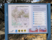
BMCC map of walks in the 
Mt. Piddington Reserve


My thanks to Judith H. for leading us on this interesting walk 

Oct 10, 2010

Callan Park - Lilyfield (1)

The 100acre plus 'Callan Park' property was purchased by the Colonial Government in 1873 for construction of a Hospital for the Insane, to be designed according to the enlightened views of the American Dr Thomas Kirkbride. It received its first patients in October 1884. 

Head Gardener's Cottage, Callan Park (1879)
The colonial architect James Barnet chose the Callan Park site for the new hospital as it was exposed to winter sun and summer breezes, was close to the city, and was isolated by the nature of its boundaries. 
The site also had a long north-facing frontage to Iron Cove. 


Iron Cove Bridge from Callan Point
In 1976 Callan Park Hospital was amalgamated with the adjoining Broughton Hall Psychiatric Clinic and become known as the Rozelle Hospital. In April 2008 the hospital was closed and staff and patients were transferred to a mental facility at Concord Hospital. 

Leichhardt Council recently released a draft master plan for Callan Park, on which people were invited to comment.


A plaque says this War Memorial (near Callan Park Oval), was erected by patients of B Ward.
It appears to cover a well.

 More info:
Friends of Callan Park
Draft Master Plan for Callan Park

Location map


The main entrance to Sydney College of the Arts.
See my post on 'Kirkbride'

See also my 'Iron Cove Bay' post

Oct 3, 2010

Sydney Olympic Games Memories


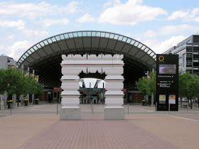
                                                                                                                                                            'Arc de Triomphe Individuel' was created by Gary Deirmendjian for the 10th anniversary celebrations of the Sydney 2000 Olympic Games. This temporary installation lies between Olympic Park station and the Stadium. It celebrates individual commitment, human effort and triumph of the athletes. The repeated outline pattern is based on a normal ECG cycle.

 The Sydney Olympics were held ten years ago between 16 September and 1 October 2000, and were followed by the Sydney Paralympics between October 18th and 29th October 2000


                                                                                                                                                                                                                          'Games Memories' - a forest of 480 poles in the forecourt of the ANZ Stadium, recalls the excitement of the many thousands of people who came to enjoy the games. The installation  is inspired by indigenous and ancient meeting places.  Around 300 of the poles list the names of the 74,000 Olympic and Paralympic Volunteers who contributed their time and services to the Olympics. Other poles interpret the spectator experience of the games.                                                                                                                      The installation was by Tony Caro Architecture in collaboration with Root Projects Australia, Donny Woolagoodja (a prominent indigenous artist) painted three of the poles, Emery Vincent Design (Graphic Design), Wax Sound and Media (Multi-Media Programs).        


                                                The Olympic Stadium, currently the 'ANZ Stadium', was originally built to temporarily hold 110,000 spectators, making it the largest Olympic stadium ever built as well as the largest stadium in Australia.
It was latter reconfigured with lesser seating capacity to suit the various football codes and other events.


This photo which shows the seating inside the Olympic Stadium during the Paralympics, is one of my own Olympic memories.


Transport: Sydney Olympic Park can be reached by Train or Bus


Sep 22, 2010

Katoomba - Furber Steps to 'Witches Leap'


Witches Leap, Katoomba

There are numerous bush walks around the Echo Point and Scenic World area. My ‘Echo Point’ post mentioned one, the Prince Henry Cliff walk.

This current post shows a few photos taken on a walk from the Katoomba Falls Kiosk on Cliff Drive, down the Furber Steps  past 'Witches Leap' into the rainforest at the base of the cliff. A sign along the way informed us that a ‘leap’ is a Scottish term for waterfall
The Three Sisters


The familiar silhouette of the Three Sisters is seen (from a distance) from a lookout below Katoomba Falls Park.

Location map for the walk

Katoomba Falls

'Wild Walks' site gives details of many bush walks in the area including 'Witches Leap Circuit' starting at Scenic World.  

Sep 9, 2010

Parramatta Park (1)

Parramatta Park
Parramatta Park is one of the largest parks in Western Sydney. It was proclaimed in August 1858 and is one of Australia's most important cultural landscapes.

Old Government House, Parramatta


Old Government House (Australia's oldest surviving public building) and Domain is included in the ‘Australian Convict Sites World Heritage Property’
It has been undergoing major restoration this year, which is the bicentenary of Governor Lachlan Macquarie.


The Bath House, Parramatta


Although it seems an upmarket Restaurant, Lauchlan’s at Old Government house has a cafe menu available for morning tea, light lunch and afternoon tea. 

A grape vine seen on the left of the photo should add to the ambiance when it is in leaf.


 The Bath House was built in 1822 with a Roman style bath for Governor Brisbane.
It was later converted into a bandstand pavilion for public use.


Parramatta can be reached from Sydney by Cityrail train (~30 minutes) or by Rivercat ferry, see my Circular Quay to Parramatta post.


For more about Parramatta Park, please is my second post on the park.

Aug 31, 2010

Wattle Day


Australia's Wattle Day centenary (1910-2010) is being celebrated on Wednesday 1 September 2010.
This wattle (Acacia amoena) was photographed on a recent walk in the Blue Mountains near Hazelbrook. Australia's national floral emblem is the Golden Wattle.

Aug 26, 2010

Hazelbrook (2)

Aboriginal Wells, Hazelbrook

These rock holes, known as the Aboriginal wells, are adjacent to the Great Western Highway just west of the Hazelbrook village shops. The rock holes, which vary in size are natural or formed holes in the rock.


The rock holes, near Gloria Park, are the remaining group of a larger cluster of holes said to be rainwater catchment wells used by travelling Darug and Gundungurra people. Smaller holes could be covered with capping stones to reduce evaporation.
The elevated pedestrian  footpath goes around the wells which can be seen in the bottom right-hand corner of the above photo.

----------------------------------------------------

Blue Mountains Gazette reported (Nov 19 2013) that: "Selwood Science and Puzzles is closing down after 16 years following the sudden and unexpected death in May of its creator David Thomson".

Aug 14, 2010

Hazelbrook Walk


The Intercity train journey, from Sydney's Central station to the mid Blue Mountains village of Hazelbrook, (93.5Km) takes about one hour 40 minutes. We walked from the northern side of the station, along Winbourn Road, past homes to the start of a bush walk in Burgess Park reserve.

Burgess Falls, Hazelbrook


The Blue Mountains City Council has recently installed signs for this walk


Oaklands Falls, Hazelbrook


Burgess Falls are not large, but like most mid mountains walks, it is a very pleasant spot to visit in all seasons. It was named as a memorial to a local World War I soldier who was killed in Belgium in 1917

There are several other small waterfalls in the area, such as the Oaklands Falls